
2025 Apparition Albedo Map of Mars
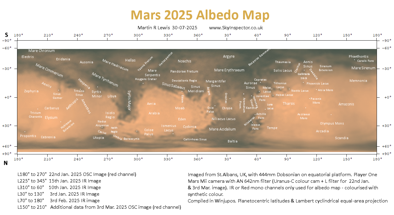
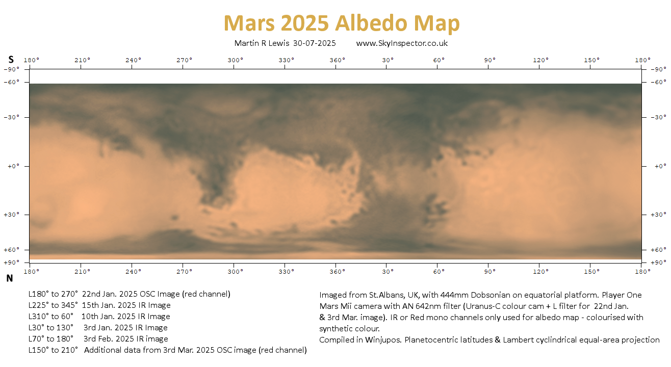
Similar methods used in this albedo map to those detailed below for the 2020 albedo map, but with Mars even smaller in diameter than 2022/23, there is significantly less detail evident.
Again this map was compiled in the Winjupos map computation function but using just six IR image and OSC images taken around opposition (early 2025).
2022/23 Apparition Albedo Map of Mars


Similar methods used in this albedo map to those detailed below for the 2020 albedo map, but with Mars smaller in diameter and less imaging opportunities, there is somewhat less detail evident.
Again this map was compiled in the Winjupos map computation function but using just five IR images taken around opposition (early December 2022).
2020 Apparition Albedo Map of Mars


Finally some excellent views of Mars in late 2020 with the planet high in the sky and over 20″ in diameter at around opposition on 13th October. This map was again compiled in Winjupos map computation function from IR images taken on six good nights around opposition, with my 444mm Dobsonian on my home-built platform.
IR images generally give improved contrast on albedo features and also suffer less from atmospheric seeing issues which tend to smear out detail. The area around longitude 340°-58° was taken from the red channel of a one-shot colour image, due to the absence of IR data on that night.
IR/red monochrome images were assembled into a map using the method described for previous apparitions below. The different sections were contrast and brightness matched in Winjupos and PaintShop Pro. To blend the adjacent sections each section was set as a different layer and overlapped its neighbours. At each join, a gradient mask was used to smoothly vary the opacity of the edges of the overlying section from 0-100% opacity. This worked really well and will be used for future apparitions.
The map was later colourised to match the full colour appearance but the colour is false and for aesthetic reasons only.
The annotated version used labelled from Ebisawa’s map and Frassati’s map and with the great help of BAA Mars guru Richard McKim, to whom I am indebted.
2014 Appartition Albedo Map of Mars

The 2014 Mars Albedo Map above was created in the same way as those shown below from 2010 and 2012, using images taken during the 2014 apparition and combining these images using the Map Computation feature in Winjupos. Despite the lower declination of Mars this opposition, the map shows some regions with significantly more detail than seen in previous albedo maps mainly due to the larger telescope used to image the planet. For this apparition I used my 444mm Dobsonian instead of the 222mm one.
Unfortunately during this apparition the weather was not so kind and there were far fewer imaging opportunities compared to the previous few apparitions. As a result some regions are not well covered, especially at around longitudes 150° and 300°. This absence of data makes the task of blending the different sections to make a seamless map nearly impossible and consequently I have decided not to go for a fully-blended map but just to soften the edges of the individual sections to make the joints less visually jarring.
2012 Apparition Albedo Map of Mars

The 2012 Mars Albedo Map shown above was created in a similar way to that described below. It was again compiled using Winjupos, but was based on seven rather than six separate images of Mars. The images I used to generate the map are listed at the bottom left-hand corner of the map. Also shown there are the longitude strips on the map that each image was used to create (click on map to see larger version). These separate images can be seen on my Mars page here.
Individual images used to create the map were taken with the set-up described in the bottom right hand corner of the map. This was with the same telescope that I used in 2010 but with a more sensitive camera attached and the use of an ASH atmospheric dispersion corrector (ADC) just before the camera to reduce dispersion effects and so improve the detail captured.
I used PaintShopPro 9 instead of Photoshop for all the blending work and colour balancing of the individual segments. Many thanks to Robin Scagell for helping with the colour rendition which was problematic due to my red-green colour blindness.
The above map was used to create a Mars 2012 rotational animation video which can be seen here.
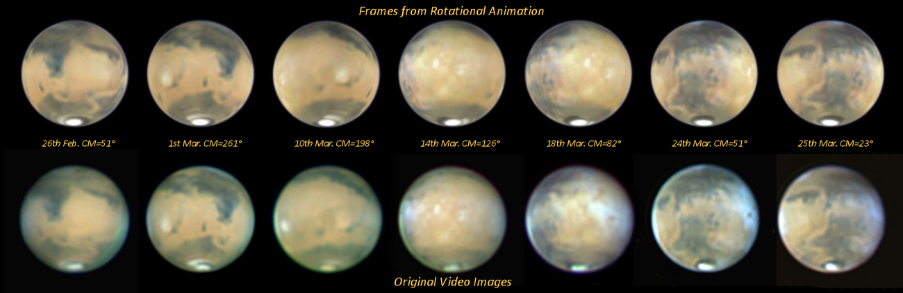
For interest, the image below compares the original images used to compile the above albedo map (bottom row) with frames from the video at the same central meridian longitudes (top row). Click on the map for a larger image to enable you to more closely compare the pairings.
For further details of the method of making one of these maps, see below in the 2010 map section.
Below see a map of Mars based on the image above which has been labelled based on information on the BAA Mars pages and with the help of Richard McKim.

2010 Apparition Albedo Map of Mars

The Mars albedo map shown above was created in WinJupos from observation of Mars that I made between 17th Jan and the 5th March 2010 using my 222mm reflector and an Imaging Source DMK21AF04AS mono webcam, together with Astronomiks RGB filters. It is this albedo map that was used to generate my Mars 2010 rotation animation.
Out of a total of 16 RGB images that I generated during the 2010 apparition, six were chosen which would give a full 360° coverage of the planet. Before combining these six to make the map, a good deal of time was first spent tweaking the orientation, hue and gamma of each image so they matched each other as closely as possible. These adjusted Mars images were then each separately loaded into Winjupos along with time and date using the ‘image measurement’ function. The map was then generated with the ‘map computation’ function.
After a lot of playing around and an acceptable rectangular projection map had been generated, further blending of the sections of the map was carried out both in Winjupos and Photoshop in an attempt to achieve a seamless final image.
I was inspired to have a go at creating my map by Jan Adelaar of the Netherlands who produced his own maps in 2005 and 2007 and who helped me produce my first albedo map from images I obtained during the 2007-2008 apparition.
My first Mars albedo map, from the previous apparition in 2007-2008, is shown below. As you see, I spent far less time matching the separate sections and did no blending work.
For those who want to have a go at using Winjupos to create a surface map of a planet from separate images, there is a link to an excellent introduction to the method here. In this document read sections 2 and 5. If the link no longer works you can download a pdf of this method below.
2007-2008 Apparition Albedo Map of Mars
